
By HistoraEDU
A migration arrow can look more certain than the research behind it. Students may leave an introductory lesson thinking that one route, one date, and one group explain the entire peopling of the Americas. Teach them to separate a physical observation from an interpretation and from a question still being investigated. The aim is not to make every conclusion seem equally doubtful. It is to make the strength and limits of a claim visible.
Start with a trace rather than a finished story
Show a photograph of fossil footprints at White Sands. Ask students what is visible before introducing the interpretation: impressions in the surface, their arrangement, and a measuring scale. Then supply the site context. The National Park Service reports evidence of human presence there roughly 21,000 to 23,000 years ago. The age comes from scientific investigation, not from looking at the photograph alone.
Make three spaces in students’ notes: observation, explanation supported by research, and question. “There are footprints” and “this photograph shows the route by which people reached the Americas” belong in different categories. The latter claim goes beyond what the image establishes.
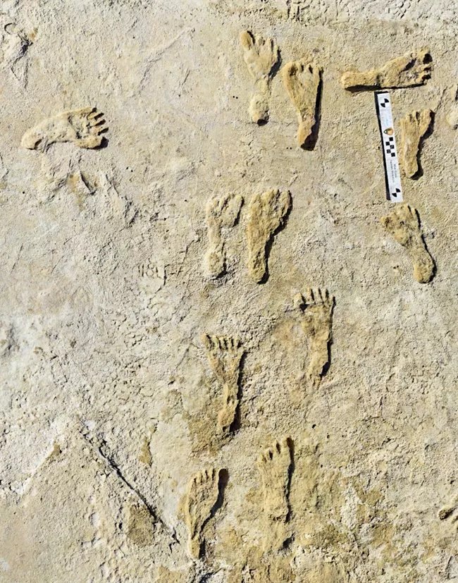
Fossilized human footprints at White Sands National Park. National Park Service photograph; date of photograph not specified on the source page. Public-domain U.S. Government work. The image alone does not establish the age of the tracks.
Make the dating evidence part of the lesson
Ask what researchers would need to know about the material above and below a footprint layer. The excavation photograph helps students see why context matters. A loose object and an object documented in a layer do not provide the same information. Have students explain why the location of a find can matter as much as the find itself.
Do not turn this into a competition to announce the oldest date. Research changes as methods and evidence are tested. A useful classroom claim names the site and the reported evidence, then stops short of inventing a complete journey, language, identity, or intention for the people who left the traces.
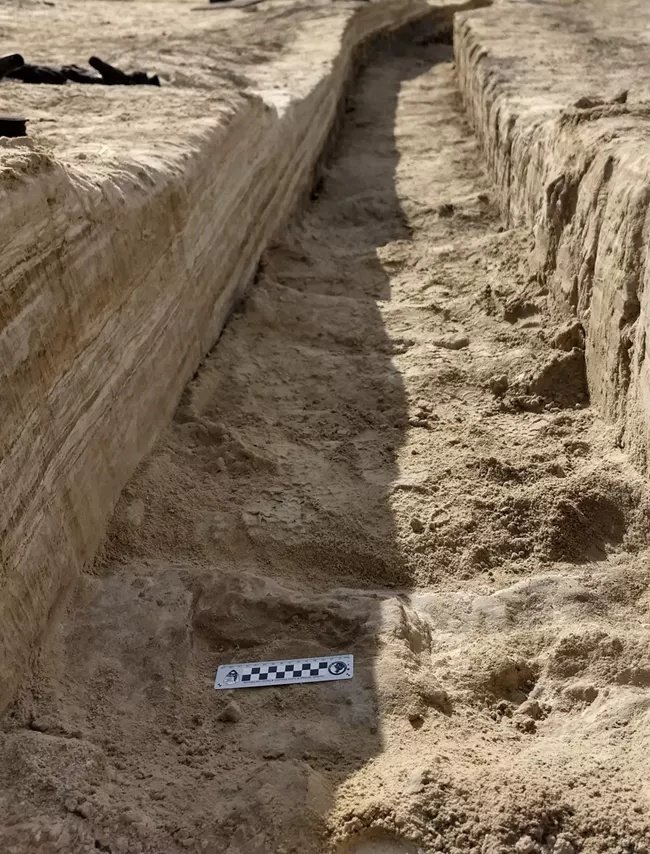
An excavation trench in gypsum soil at White Sands National Park. National Park Service photograph; date not specified on the source page. Public-domain U.S. Government work.
Replace the narrow bridge picture with a changing region
Explain that lower sea levels exposed a broad region between northeastern Asia and North America. Beringia was not a constructed bridge or a single line that everyone crossed at one moment. The National Park Service describes evidence for varied environments, including shrub tundra, grasses, and flowering plants. Avoid replacing one oversimplification with a picture of an identical grassland everywhere.
A modern photograph of granite tors helps locate a real landscape, but it is not a photograph of the Ice Age land bridge. Ask students to write a caption that states both facts. The exercise is small, but it shows whether they understand that an image’s present appearance is not automatically evidence of every past condition.
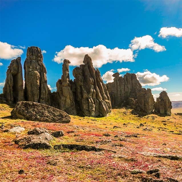
Granite tors near Serpentine Hot Springs in Bering Land Bridge National Preserve. National Park Service photograph by Derek Wier; date not specified. Public-domain U.S. Government work. Modern landscape, not an image of the exposed Ice Age land bridge.
Compare hypotheses without presenting every proposal as equally supported
Use a carefully selected current research summary to distinguish evidence for people at a site from an explanation of their route. An inland corridor and a coastal route raise questions about timing, environment, and surviving evidence. A line on a classroom map summarizes an interpretation; it does not preserve every movement made across many generations.
Clovis stone technology is important archaeological evidence, but “Clovis” should not stand for the first people everywhere or for one timeless Indigenous culture. Ask students what an artifact can support and what it cannot tell them without more context. Do not infer a community’s entire social organization from one tool type.
Keep Indigenous knowledge and living communities in view
The Smithsonian’s Native Knowledge 360 framework stresses the diversity and continuing presence of Native nations, including distinct origin traditions. Archaeological models should not be used to rank those traditions or demand that a student speak for a community. Use sources created or approved by the specific nation when teaching its history, and respect restrictions on stories or cultural knowledge.
End with a revision task: “A migration map tells the complete story of all Indigenous peoples.” Students rewrite the sentence using evidence and a meaningful limit. Look for a distinction between the broad research question and the histories of particular communities, not a ritual phrase such as “nobody knows anything.”
Preview readings against current research before assigning them
Choose a reading for a specific teaching purpose, rather than treating any one introduction as the complete story. The resources below address different parts of the unit. For the two geography readings, use the selected questions and teacher notes described here alongside the linked National Park Service evidence. Preview the remaining readings for the age, reading level and regional focus of your class; the suggestions below describe their listed topic, not a verification of every claim or answer.
Keep the evidence comparison precise
For Ice Age Migration and Bering Land Bridge, start with the explanation that water stored in glaciers lowers sea level and exposes land. Select the geological-process question in the first section of each reading. Do not turn that physical mechanism into proof of a single first route or crossing date.
Pair any migration-date statement with the National Park Service account of White Sands. Its footprint evidence concerns human presence at a particular site roughly 21,000–23,000 years ago; it does not date every migration or identify the route those people followed. Ask students to name the site, evidence and limit of each statement.
Use the NPS Beringia environment summary to qualify a uniform-grassland picture: sediment evidence indicates varied vegetation, including shrub tundra, grasses and flowering plants. Do not ask students to reproduce the readings’ animal lists as a verified list for every part of Beringia.
Distinguish the flooding of a land connection from complete isolation of all people. The NPS account describes continuing connections among peoples of Beringia after submersion. Do not assign the Bering reading’s isolation vocabulary example or universal ancestry statement as an unqualified factual conclusion. Questions about genetic research need population-specific, dated sources; genetic models do not define a living Native nation’s identity.
For this short lesson, leave the readings’ wider ancestry and route conclusions outside the selected task. Close with an observation–interpretation–question chart using the linked evidence summaries, rather than an answer that asks students to memorize one migration story.
First Americans Reading Comprehension | Native American History Worksheet
View this HistoraEDU resource on TPT
The listing describes a broader introduction to Indigenous diversity and continuing presence, in an editable Google Doc for grades 7–12 with a higher reading level. Consider it when your next lesson moves beyond migration; preview the reading before pairing it with a source from a specific Native nation.
Ice Age Migration to America Reading Passage | Native American History
View this HistoraEDU resource on TPT
For this evidence lesson, select the glacier-water and sea-level explanation in “Climate, Ice, and a Changing World” and its second comprehension question. Use the teacher notes above to separate this physical process from claims about the date and route of the first migration; this is not a recommendation to assign every section unchanged.
Bering Land Bridge Reading Comprehension | Native American History
View this HistoraEDU resource on TPT
Use the geological-process question in “The Ancient Geography of the Bering Strait” to connect ice storage, lower sea level and exposed land. Pair it with the current NPS environment account, and keep the wider ecosystem, isolation and ancestry claims outside this short selected task.
Paleo-Indians Reading Passage and Questions | Early American History
View this HistoraEDU resource on TPT
The listed focus is early North American life, stone technology and environmental change. It is a possible next reading for a lesson about adaptation; preview its time and place distinctions rather than presenting one way of life as universal.
Clovis Culture Reading Comprehension | Native American History Worksheet
View this HistoraEDU resource on TPT
The listing focuses on Clovis tools and includes pre-Clovis findings. Consider it for a follow-up about how discoveries change interpretations. Pair the topic with a current archaeological source; the tool type should not stand for every early community.
Early American Hunter-Gatherers Reading Passage and Questions
View this HistoraEDU resource on TPT
The listed focus is hunting, gathering, environmental knowledge and community life. Consider it for a follow-up on how people use local resources, after selecting a particular place and period; avoid treating hunter-gatherer communities as identical.
Sources and image credits
White Sands fossilized footprints and research context
Beringia environment and scientific evidence
Native Knowledge 360 essential understandings
Product thumbnails: HistoraEDU, reproduced from the exact current TPT listings at the owner’s request. Archival sources do not endorse HistoraEDU or its products. No claim to original U.S. Government works.
