
Header credit: U.S. Geological Survey, National Geospatial Program. Public-domain Vienna map-animation frame, labeled 1966 (1971); editorial layout by The Instruction Edit.
A road symbol appears on one map but not another. It is tempting to turn the later map’s date into the road’s opening date. Before making that move, check what the date describes, what each edition includes and whether the two sheets use comparable scales and symbols. A difference between representations is evidence to investigate—not automatically a dated construction event.
USGS topoView provides access to the Historical Topographic Map Collection and US Topo maps. Its value for a local-history task is access to editions and their records, not merely an attractive old-map background. This evaluation uses official documentation and a published static example. It does not certify the live interface, device performance or accessibility, and the images below are not fabricated interface captures.
Start with the map pair—and name its limits
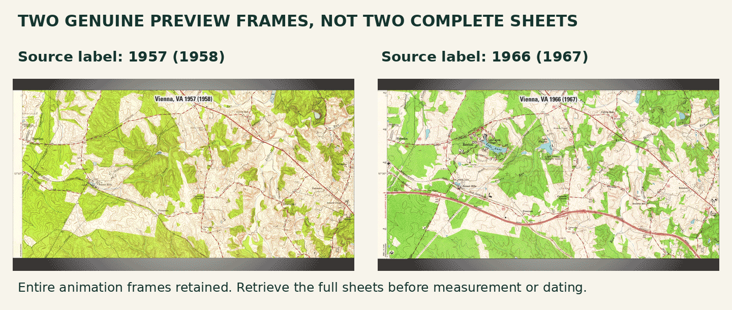
Figure 1. Uncropped stills from the USGS “Change Over Time” animation for the Vienna, VA quadrangle, labeled “1957 (1958)” and “1966 (1967).” These are excerpts in a published animation; the full map collars and complete legends are not shown.
In the later preview, a prominent red double-line route runs across the lower part of the view; that route is not displayed in the same way in the earlier frame. This is a located visual comparison. It is not yet a claim that a particular road was built, opened or surveyed between the two displayed years.
The exact animation record identifies the Vienna quadrangle and permits public-domain reuse. It does not supply the complete metadata needed for a finished two-map investigation. That limitation makes the preview useful for an opening question, but insufficient for measurement, a complete symbol interpretation or a precise event chronology.
For the real task, retrieve both complete sheets and save their stable records or file identifiers. Keep the collar—the information around the mapped area—rather than cropping it out for a cleaner slide. Compare the same geographic area at the same source scale where possible. If different scales are necessary, make that difference part of the reasoning, not a hidden design choice.
The year in the title is not the whole date record
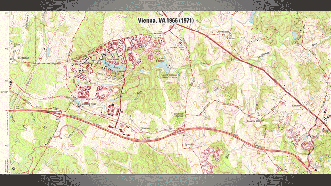
Figure 2. A third exact animation frame reads “Vienna, VA 1966 (1971).” The repeated 1966 with a different parenthetical year is a reason to inspect the underlying records. The caption does not relabel either year as a survey, revision or printing date.
USGS explains that apparently duplicate maps may be revisions or reprints. Its date guidance distinguishes the year of base compilation or significant revision, the imprint year, photo inspection and revision years, field checking and survey dates. Those labels refer to different stages of map production; none should silently become the date when every depicted feature existed.
For this preview, record the label literally: “1966 (1971).” Leave the survey, revision and print fields unverified until the full sheet or authoritative record identifies them. Do not fill the blanks by guessing what the parentheses mean. A careful incomplete record is more useful than a confidently mislabeled one.
The topoView guide describes map records with dates, scale, download options and additional information. Use those details alongside the printed sheet. When two entries share a displayed year, compare their other metadata before discarding one as a duplicate. This is documentation-based guidance, not a claim that we tested every current interface control.
Make the metadata part of the comparison
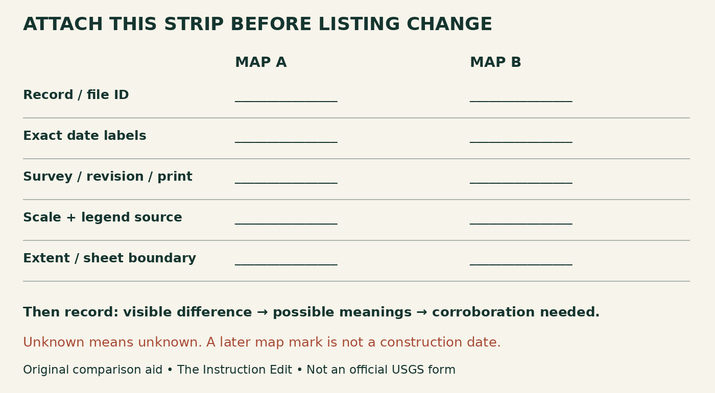
Figure 3. Original two-map metadata strip and comparison aid, The Instruction Edit. Blank fields are intentional: transfer the evidence from the selected records and complete sheets rather than copying dates from an animation title.
A worked preliminary entry for the displayed pair would say: “Area: Vienna, VA quadrangle preview. Labels: 1957 (1958) and 1966 (1967). Full-sheet identifiers, date roles, source scales and legends: not verified from these frames. Observation: a conspicuous red double-line route is represented differently across the lower part of the view. Construction date: not established.”
That entry tells the teacher what to do next. Obtain the full editions and identify the route symbol in the applicable legend. Check whether the earlier edition could omit, generalize or classify the feature differently. Then seek a dated source suited to the historical claim, such as a transport-agency opening record or a contemporary report. Those are proposed corroborating sources, not records located for this example.
After verification, write two statements instead of one: what differs on the maps, and what the additional evidence establishes about the place. If the second source is unavailable, keep the first statement bounded. Do not make a guessed construction year the price of completing the worksheet.
Select maps that can carry the question
If the question is how a road network was represented across editions, these images can begin a discussion. If it is when a named road opened, map comparison needs a different kind of corroboration. If it is whether woodland area changed, first check the legend, scale, mapped extent and production notes; a change in green tint alone is not a measured land-cover result.
Digital enlargement also changes the size of symbols on the screen, not the source map’s information content. For a distance task, use the complete map and an appropriate scale workflow. We have not measured these previews or established their source scales. Never infer precision from a large projected image.
The reusable rule is simple: no change list until both metadata strips are attached. Allow “unknown” and “not shown,” but require a next action. Learners can describe a visible difference orally or in text while the teacher provides enlarged legends or transcriptions of the collar. Removing access barriers should not require pretending uncertain metadata is known.
The exact USGS animation is public domain. We extracted complete still frames without crop or recoloring and retained its own labels; its preview limits remain visible. This does not establish rights for every modern basemap, third-party layer or screenshot in an interactive service. Our strip and classroom suggestions are original, not USGS-authored or endorsed. No classroom results or assistive-technology audit are claimed.
Sources and next step
USGS: topoView resource record; Vienna change-over-time media record; guidance on maps with the same date; topoView help guide. Sources checked October 30, 2026. Non-affiliate evaluation.
Before asking what changed, attach the two metadata strips. Then write one claim the maps support and one claim that still needs another source.
