
By HistoraEDU
If a student thinks West Berlin was simply the eastern edge of West Germany, the next Cold War lesson starts on a shaky foundation. The vocabulary may be correct while the mental map is wrong. Before asking students to explain containment, give them a short nested-map routine: Europe, occupied Germany and occupied Berlin. The goal is not a beautifully colored worksheet. It is an accurate explanation of how a divided city sat within a larger occupation landscape.
Diagnose the location problem before adding causes
Ask students to sketch where they think Berlin was in relation to Germany’s western occupation zones. Label this a quick model, not an assessed drawing. Offer three possible relationships: Berlin on the western edge, Berlin straddling the boundary between the western and Soviet zones, or Berlin surrounded by Soviet-occupied territory. Have students choose and explain their reasoning before showing the reference map.
Use a dated classroom atlas or verified historical map of the 1945 occupation arrangement, not today’s political map. Check that its legend distinguishes the four occupation zones from areas east of the Oder–Neisse line under Polish or Soviet administration. A modern outline or an unlabeled color key can introduce a second misconception while you are trying to fix the first.
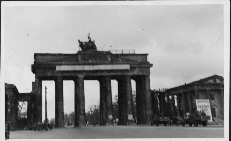
Brandenburg Gate, Berlin, July 1945. Richard Beckman; Harry S. Truman Library & Museum, 2017-1088. Public domain. This street-level view locates a real city; it does not show the boundaries of its occupation sectors.
Zoom in without changing the date
Set out three panels with the same reference date: late 1945. The Europe panel locates Germany. The Germany panel distinguishes American, British, French and Soviet occupation zones and marks Berlin. The enlarged Berlin panel shows the city’s separate four-power sectors. Keep one key for occupying powers, but make the panel titles explicit so students do not mistake a city sector for a large German zone.
A January 1947 State Department analysis describes Greater Berlin as a jointly occupied area within the Soviet zone and identifies its American, British, French and Soviet sectors. Use that dated record to check the central relationship. The earlier May 1945 draft summary of occupation agreements also treats Germany’s zones and Greater Berlin’s joint occupation as separate provisions; identify it as a draft summary, not a final map.
Model two sentences: “Berlin was surrounded by the Soviet occupation zone. Berlin itself was divided into sectors occupied by four powers.” Ask students to point to the appropriate panel for each clause. If they point to the same colored region for both, stop and rebuild the distinction before introducing a crisis.
Make the legend explain authority, not personality
Ask what a zone’s color means. It represents an occupation authority, not proof that every resident shared that government’s beliefs. A border or sector line cannot establish how everyone thought, voted or experienced occupation. Keep political control, economic ideas and individual experience separate.
The photograph of a troop review provides a concrete example of military presence during the occupation period. Students can connect the caption’s date and location to their map. They should not use the line of vehicles to infer the exact sector boundary or assume that the photograph depicts a new battle.
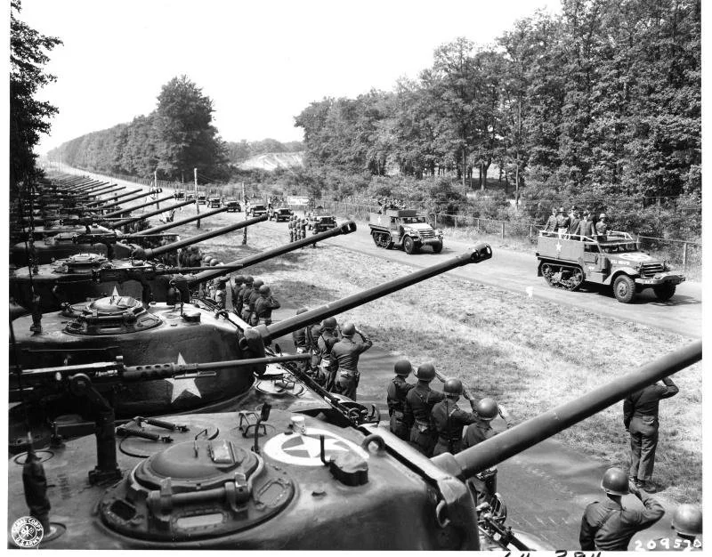
Henry Stimson reviews the 2nd Armored Division in Berlin during the Potsdam Conference, July 20, 1945. U.S. Navy; Harry S. Truman Library & Museum, 64-384. Public domain. This is a troop review, not combat or a photograph of an occupation border.
Add later dates on new panels, not over the old one
Only after students can explain the occupation map should they add a separate 1949 panel for the emergence of the Federal Republic of Germany and the German Democratic Republic. Keep Berlin’s special four-power status visible rather than treating the city’s western sectors as an ordinary piece of the Federal Republic. Do not backdate those states to 1945.
This is also why a 1961 Wall photograph should not stand in for the original occupation arrangement. Put later events on a timeline beside the maps, not into the legend of the 1945 map. Students need to know whether a label describes geography, governing authority or a later physical barrier.
For a quick correction task, offer: “The four German occupation zones were four parts of Berlin.” Have students rewrite it using both levels of the nested map. A strong answer distinguishes the country-scale zones from the city-scale sectors without adding an unnecessary list of later events.
Zoom back out before teaching aid or alliances
When the class moves to the Marshall Plan, return to the Europe panel. Economic recovery was not a program confined to one Berlin sector. When introducing NATO, use a separately dated 1949 membership map at a wider North Atlantic scale. Do not color the 1945 occupation map as if it were already a NATO map. The organization included the United States and Canada as well as Western European countries.
The same place can appear in several stories without the maps describing the same thing. Ask students to label each map’s question: Who administered this territory? Where was recovery assistance directed? Which states belonged to this alliance at this date? A useful map answers a stated question; its colors should not silently switch meaning.
Use the rebuilding photograph below to keep people’s lives visible alongside the political map. Its July 1946 date precedes the Marshall Plan. It documents clearing work in a Berlin street, not the effects of a program that had yet to begin.
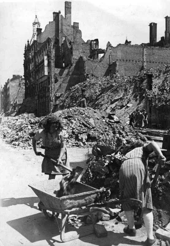
Clearing work in Jägerstraße, Berlin, July 1946. Bundesarchiv, Bild 183-H29659 / Peter Cürlis / CC BY-SA 3.0 DE. Commons version previously cropped by a contributor; no further crop here. Not evidence of Marshall Plan results; no endorsement implied.
Check the mental map with an explanation
End by asking students to finish: “Western sectors of Berlin could be separate from the western zones of Germany because…” They should explain the city’s location and separate occupation arrangement, not simply repeat “the Cold War.” Let them point to the two panels while speaking before writing.
For support, provide the words city, zone and sector with clear definitions. For extension, ask students what a map of occupation authority cannot tell them about a resident’s daily life. This preserves the map’s explanatory value without pretending geography answers every historical question.
Choose the reading that matches the next question
Use one focused reading after the spatial check, not all four at once. Cold War Origins fits the move from wartime cooperation to postwar rivalry. Cold War Ideologies supports discussion of political and economic ideas without treating map colors as individual beliefs. The Truman Doctrine and Marshall Plan reading fits the wider aid discussion, while the Containment reading supports later work on policy and NATO.
The nested-map routine is an additional teaching suggestion in this article. These resources are reading-comprehension worksheets; the links below do not promise a complete historical atlas, a ready-made set of the three maps, or the archival photographs used here.
Cold War Ideologies Reading Comprehension | Democracy vs Communism
View this HistoraEDU resource on TPT
Use for political and economic ideas after students can distinguish a map of authority from residents’ individual beliefs.
Cold War Origins Reading Comprehension Worksheet | From Allies to Enemies
View this HistoraEDU resource on TPT
Use for the transition from Allied cooperation to postwar rivalry once the occupation geography is secure.
Truman Doctrine & Marshall Plan Reading Comprehension | Cold War Containment
View this HistoraEDU resource on TPT
Use when zooming back out to the geographic scope and purposes of aid; the map routine is supplied separately by the teacher.
Cold War Containment Reading Comprehension | Domino Theory & NATO Worksheet
View this HistoraEDU resource on TPT
Use for containment and NATO context after distinguishing the occupation map from a later alliance map.
Sources and image credits
January 1947 State Department analysis of Berlin’s separate sectors and location
May 1945 draft summary: occupation zones and Greater Berlin
Office of the Historian: Germany country history
1966 US Embassy assessment of Berlin’s special status and the 1949 arrangements
Office of the Historian: Berlin’s occupation geography
Office of the Historian: European recovery context
Office of the Historian: NATO, 1949
Reconstruction photograph license CC BY-SA 3.0 DE
Product thumbnail reproduced from the exact HistoraEDU listing at the owner’s request. Historical photographs are separate evidence, not product endorsements.

