
HistoraEDU | Build an honest First Americans timeline
A timeline can be neatly labeled and still teach the wrong lesson. If every event gets the same amount of wall space, students may mistake visual spacing for elapsed time. If a research range becomes one sharp dot, they may mistake a display choice for a precise date. Use two clearly labeled scales and one documented archaeological example to make those choices visible. The purpose is to read time responsibly, not to squeeze the entire history of Indigenous peoples onto one strip.
Start with a site and a range
Use the National Park Service’s White Sands footprint account as a bounded example. The page reports research placing human presence at the site roughly 21,000 to 23,000 years ago. Label the entry “White Sands human footprint evidence” rather than “the first people arrive in America.” Evidence at one location does not date every arrival or tell students the route those people traveled.
For this classroom model, use the rounded 21,000–23,000-year span as a display band. Do not call it the exact age of every footprint or a statistical confidence interval. Keep the source beside the label so students can see that the simplified range comes from an account of research, not from measuring the photograph.
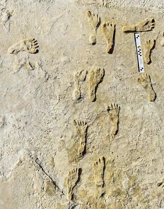
Fossilized human footprints at White Sands National Park. National Park Service photograph; date of photograph not specified on the source page. Public-domain U.S. Government work. The image alone does not establish the age of the tracks.
Build an overview with a stated scale
Draw a 25-centimeter line. Label the left end 25,000 years ago and the right end the present. At one centimeter per 1,000 years, the entire line represents 25,000 years. Mark every 5,000 years clearly, with older dates to the left. These centimeter measurements are an instructional layout choice, not measurements from an excavation.
Place the rounded White Sands band from 23,000 to 21,000 years ago. On this line it starts 2 centimeters from the left edge and ends 4 centimeters from that edge. Its width is 2 centimeters because the represented span is 2,000 years. Have students check those three numbers before attaching the label.
Now ask where a 100-year interval would fit. At this scale it occupies one millimeter. The problem is not that the interval is unimportant; it is that the scale makes it hard to label. Use that observation to introduce a second panel rather than quietly stretching the recent end of the same line.
Zoom in without pretending time has changed
Draw a separate 20-centimeter detail line covering 24,000 to 20,000 years ago, again with older dates on the left. Label its scale one centimeter per 200 years. The 23,000–21,000 band now runs from 5 to 15 centimeters from the left edge, a width of 10 centimeters. It represents the same rounded span as the overview band.
Connect the detail panel to the matching interval on the overview with a bracket and the words “enlarged detail.” The band is five times wider because the scale changed from 1,000 to 200 years per centimeter, not because the people lived through five times as much time. Do not join the two axes as if their centimeter marks were interchangeable.
Ask students to explain the display to a partner: “This band looks wider here because ___. Both panels still represent ___.” If the response says the second panel shows an older event, return to the endpoint labels. The exercise is about scale, not about generating a second historical claim.
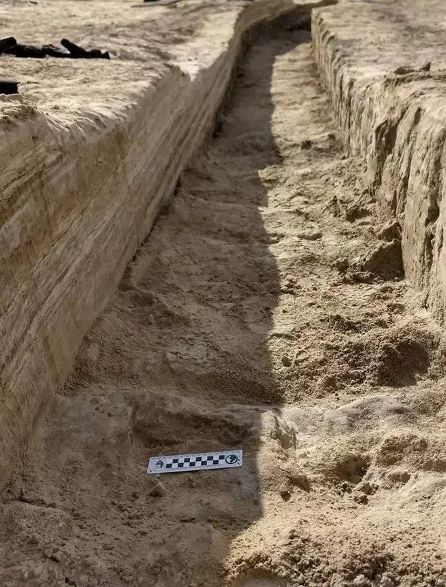
An excavation trench in gypsum soil at White Sands National Park. National Park Service photograph; date not specified on the source page. Public-domain U.S. Government work.
Do not turn a photograph into a clock
The excavation photograph shows a trench and sediment layers. It can help explain why researchers record the context of a find, but the visible depth is not a ready-made calendar. Do not ask students to assign a fixed number of years to each centimeter of soil or infer an age from the color of a layer. Dating requires evidence and methods beyond this photograph.
Keep three labels distinct: the age assigned to the archaeological evidence, the date of the modern photograph, and the scale chosen for the classroom drawing. Here the source does not supply a photograph date, so the caption says so. An unknown photo date does not make the archaeological evidence undated, and an archaeological age does not tell us when the camera was used.
Keep geography and chronology in separate jobs
A Beringia reading can introduce how water stored in large ice sheets lowered sea levels and exposed land between Asia and North America. That physical mechanism does not establish one universal crossing date. If students add a climate or geography band to the timeline, require a dated source for that particular band; do not infer its endpoints from a migration arrow or from the White Sands range.
The modern Bering Land Bridge National Preserve photograph below helps students locate a real landscape. It is not a view of the exposed Ice Age connection and cannot supply dates for a route. Keep it next to a caption about place rather than using it as proof of a single migration sequence.
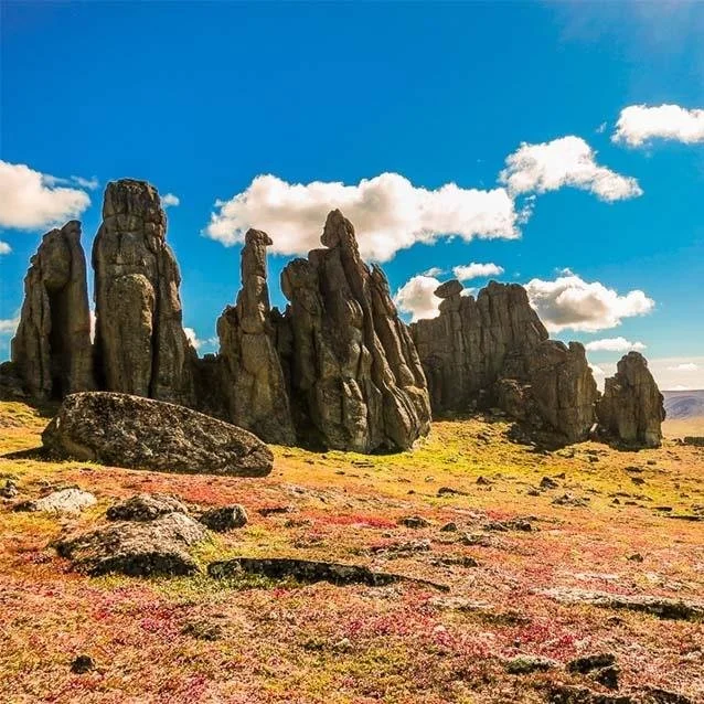
Granite tors near Serpentine Hot Springs in Bering Land Bridge National Preserve. National Park Service photograph by Derek Wier; date not specified. Public-domain U.S. Government work. Modern landscape, not an image of the exposed Ice Age land bridge.
Avoid an empty ending
A deep-time activity should not leave Indigenous peoples stranded at the distant left end of a display. The Smithsonian’s Native Knowledge 360 framework emphasizes distinct communities, changing histories and continuing presence. Keep the overview’s present endpoint visible, and explain that this one-site exercise is not a complete community history. A follow-up about a living Native nation should use that nation’s own public sources and appropriate permissions.
Do not grade a community’s origin traditions against this classroom scale exercise or ask a student to speak for a nation. Archaeological dating and community histories have purposes and contexts that a single strip cannot contain. The task here is to describe what a particular research-based band represents and what it does not.
Assess the legend before adding more dates
Give students an unlabeled copy of the two lines and ask them to add endpoint labels, scales, the same dated band and an enlarged-detail label. Then ask for one sentence explaining why the band widths differ and one sentence limiting the historical claim. A correct answer should preserve the site, the rounded range and the distinction between a date estimate and a route.
For readers who need support, supply the source statement and endpoint labels while leaving the band placement to them. For extension, let students choose a new physical length and calculate a consistent scale. Changing the paper size is allowed; silently changing the meaning of equal spaces is not.
Select companion readings without borrowing their dates uncritically
The two-scale construction and White Sands band are teacher-added activities, not a promised template inside the resources below. Use the current NPS evidence for the band. For Ice Age Migration and Bering Land Bridge, the selected-use suggestions are deliberately narrow: the glacier-water/sea-level mechanism and the first-section geological-process question. Do not transfer their wider route, date, ecosystem, isolation or ancestry statements to the timeline as if this article had verified them.
For the other readings, the cards describe the current listed topic and format, not an audit of every answer. Preview each reading against the period, place and current evidence you plan to teach. No purchase is needed to draw and discuss the two scales above.
First Americans Reading Comprehension | Native American History Worksheet
View this HistoraEDU resource on TPT
The listed editable Google Doc introduces Indigenous diversity and continuing presence for grades 7–12, with a higher reading level. It can support a follow-up beyond the timeline; preview it and pair any specific community history with that community’s public sources.
Ice Age Migration to America Reading Passage | Native American History
View this HistoraEDU resource on TPT
For this lesson, select the glacier-water and sea-level explanation in Climate, Ice, and a Changing World and its second comprehension question. Use it to explain a physical mechanism, not as authority for the exact White Sands range or a single first migration date. This is not a recommendation to assign every section unchanged.
Bering Land Bridge Reading Comprehension | Native American History
View this HistoraEDU resource on TPT
Select the geological-process question in The Ancient Geography of the Bering Strait to connect ice storage, lower sea level and exposed land. Keep broader ecosystem, isolation and ancestry conclusions outside this short task; they are not needed to calculate the display scale.
Paleo-Indians Reading Passage and Questions | Early American History
View this HistoraEDU resource on TPT
The listed reading concerns early North American life, stone technology and environmental change. Consider a selected passage for a later adaptation lesson after checking its regional and chronological scope. The timeline should not imply one uniform way of life across all places and periods.
Clovis Culture Reading Comprehension | Native American History Worksheet
View this HistoraEDU resource on TPT
The current listing describes Clovis tools and pre-Clovis discoveries. It is a possible follow-up about how archaeological interpretations change. Establish any tool dates from a current archaeological source before adding them; this article supplies no unverified Clovis date band.
Early American Hunter-Gatherers Reading Passage and Questions
View this HistoraEDU resource on TPT
The listed editable reading focuses on hunting, gathering, environmental knowledge and community life. Use it only after selecting a particular place and period for discussion; its broad subject is not a single event to place at one point on the timeline.
Sources and image credits
White Sands fossilized footprints and dating research context
Beringia geology and environment
Native Knowledge 360 essential understandings
National Park Service image reuse notice
Product thumbnail reproduced from the exact HistoraEDU listing at the owner’s request. Historical photographs are separate evidence, not product endorsements. No claim to original U.S. Government works. National Park Service photographs are credited individually; neither the agency nor the people represented endorse HistoraEDU.
